August 23, 2019
Software for Soil: Computer Assisted Design can Check Erosion
contributor: Carlos Garcia Lanchares
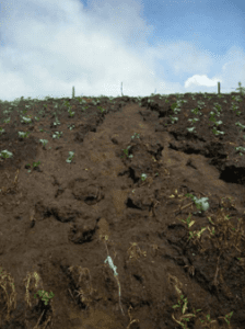
Soil erodes from a field of crops. Photo: Revilla, E.L. (see * below).
The soil is in trouble. About one-third of the world’s land is moderately to highly degraded, suffering from erosion, salinization, acidification or chemical pollution or some combination of those (FAO, 2015). Erosion in particular poses a major threat to global food security. Runoff carries away 25-40 billion tons of topsoil every year, reducing crop yields and impairing the soil’s ability to store and cycle carbon, nutrients, and water. This degradation of soil quality is a considerable setback to achieving the UN’s Sustainable Development Goal 2 in the 2030 agenda: Zero Hunger.
Software solutions
Software can help. Simulation software can predict erosion events before they occur.
Simulations can detect dangerous events such as landslides or factors that affect the stability of a surface, as shown in the images to the left. The software identifies the specific area technicians should address. It can then perform simulations of mitigation strategies, such as building dykes or spreading vegetal waste on the soil as a rain cover.
While simulation software is a useful tool for addressing soil erosion mitigation, there is still work left to do. Most existing tools are limited by the number of variables that can be inputted, such as heterogeneity of a surface, variability of rain velocity along a surface, and change of land use, which decreases the accuracy of the model and the ability for technicians to mitigate erosion-related risks.
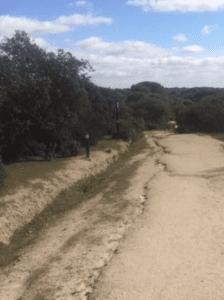
Soil erodes from a path in Monte del Pilar. Photo: Carlos Garcia Lanchares
Two models that allow for a greater input of variables include:
- RUSLE 2. Created by the United States Department of Agriculture, this software can analyze a longitudinal section by considering the variability on slope and length and its influence on runoff velocity, its land use, and the rain characteristics. However, it cannot model the effect of rain that moves in multiple directions, reducing its predictive power. It also cannot measure loss of soil in concentrated streams.
- Geographical Information System models. This software analyzes the variability of topography, but does not consider the influence of the velocity vector of the water sheet along a hillside.
There is a software tool that can account for some of the missing dimensions in the two listed above.
Computer Assisted Design (CAD) fluid simulation software could be a powerful tool for analyzing solutions to soil erosion. CAD is traditionally used in other fields such architecture, civil construction, or chain production. Soil conservationists, however, can repurpose applications built for other tasks. Namely, an application called Building Information Modelling (BIM) analyzes the effect of factors such as wind on city buildings, as shown in the image below.
What sets BIM apart from similar tools is that it analyzes not only the direction that the wind would take, but also the velocities that it will reach. By integrating a similar model into soil simulation, we take one more step toward the consideration of every important variable in predicting soil losses. This model could enable more effective interventions.
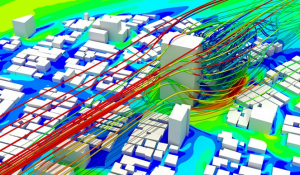
This image shows a simulated variation of wind vectors around a building, created in Autodesk CFD. Image: Churazova ,2019
Barriers
It could help to develop more tools to mitigate soil erosion, but several barriers to implementation exist. One is the cost. The agriculture sector represents only 4 percent of the world’s total gross domestic product (The World Bank, 2017), suggesting that it may be difficult to incentivize the purchase of new software tools. GDP, however, is not always a good indicator of the viability of new investments. A cost-benefit analysis is needed to demonstrate how using these tools could ultimately be profitable for companies in the long run. In addition, companies should consider the impacts to people if they do not successfully detect and mitigate erosion risks. If they do not act, how will their inaction affect the ability to feed?
CAD simulation possibilities for soil simulation are still relatively unexplored. However, they are promising tools and should be further investigated for their ability to help address the issue of soil erosion and, ultimately, feeding the world’s population.
Resources for Further Study
Churazova, A., 2019, Pedestrian Wind Comfort: CFD Wind Analysis & Validation with Experiments, Simscale.
FAO, 2019, The Global Symposium on Soil Erosion – GSER19.
FAO, 2015, Soils are endangered, but the degradation can be rolled back,
The World Bank, 2017, 4.2. World Development Indicator: Structure of output.
Lanchares,C.G., 2017, “Cartography and signaling of routes for MTB (Mountain Bike) through GPS and GIS techniques and estimation of erosión through RUSLE 2: Application in “Monte del Pilar”.Majadahonda”. Bachelor thesis, Universidad Politécnicas de Madrid
NCRS, IA 2004, Choosing the Planning Area of a Field by “Dominant Critical Area”
*Revilla, E.L., 2008, Estudio del factor de vegetación “C” de la ecuación universal de pérdidas de suelo revisada “RUSLE” en la cuenca del río Birrís (Costa Rica), Trabajo fin de Carrera, Universidad Politécnica de Madrid.


26-07-2022 08:07:58 AM
CYFAhead says: