
UP Noah
University of Philippines
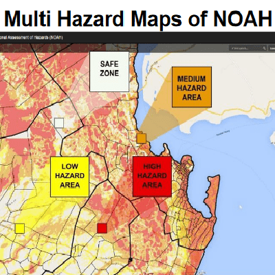
A remote sensing-based application used as a risk reduction and management tool in case of threat of severe weather events.


UP Noah (University of Philippines Operational Assessment of Hazard Centers) provides a way to raise awareness of hazards and extreme events (floods, landslides, storm surges, volcanoes and earthquakes) in the Philippines, by mapping the risk areas through the cartographic information of the satellite Himawari. It provides users with data on the temporal and physical location and the grade of an event to manage events in advance.
The University of Philippines, the creator of this service, is located in Quezon City, Philippines.
Philippines
The University of Phillippines
Free access
Goal 11: Sustainable cities and communities
Local government units, community leaders, policymakers, planners, and families to prevent and mitigate disaster